
In this Member Monday we discuss how DroneSense has applied drone technology to enhance public safety.
Today, drones are being used for everything from aerial photographs to grocery delivery. But Austin-based DroneSense is harnessing drone power to help public safety organizations and first responders expand situational awareness, and ultimately save more lives.
Though many new technologies impose a steep learning curve, DroneSense’s software platform makes it easy for public safety organizations to learn and use their product. By implementing technology that is “drone agnostic,” users who have been trained on DroneSense’s Flight Control software can apply their skills to any drone and smart device equipped with the app. Users can also use DroneSense’s software to train via flight simulators, create autonomous flight plans, and monitor multiple drones simultaneously. In addition to flight control, DroneSense also offers a management solution for accountability and a command center for unprecedented collaboration and offline capabilities.
DroneSense’s comprehensive set of features allow public safety organizations to utilize their software in a variety of situations. For example, law enforcement officers could use a drone to respond quickly to in-progress situations, assess crime scenes before personnel arrive, or even aid in the pursuit of fleeing suspects on foot or in vehicles. Drones may also be used to provide real-time video for SWAT teams and inspect potential weapons or explosives without putting humans at risk. The software can also implement thermal imaging to locate missing persons, or help incident commanders decide whether an access point in a burning building is safe for first responders to enter. Additionally, drones can be used to help accurately reconstruct the scene of a crime or car accident, to both lower costs and time for investigators. Drones can provide great utility to the public safety 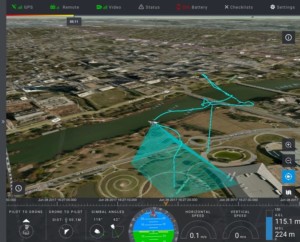 organizations that use them. DroneSense helps increase the safety of first responders, makes their work more efficient and cost-effective, and provides decision-quality data to protect and save the citizens they serve.
Aside from first responders, DroneSense’s management feature is very useful for government entities. The feature provides a full system of record for users by tracking all aspects of the drone program, which strengthens the accountability and transparency of each drone use to their respective cities. Drone technology continues to evolve, but DroneSense has already grasped begun to harness its potential to make our lives and communities safer.
Look out for drones using DroneSense software in your cities and communities, as their unmanned aerial systems help to usher in the next evolution in public safety. The next time you call on a first responder, don’t be surprised if a drone is actually the first one to arrive!
To learn more about DroneSense please check out their website at http://www.dronesense.com/
Photo provided by DroneSense.