Tracking steps is a relatively easy thing to do for a wearable: at its core, a step-counter counts bounces. But just like in Inception, we can go deeper into the world of movement tracking. The wearables on your arm, clipped to your belt, and in your pocket all require a little help from above if they want to get a true read on the distance you traveled during a run, hike, walk, bike, etc. For that, we can thank some old Cold War-era military technology.
Global Positioning System
Global Positioning Systems (GPS) use a constellation of 24 satellites, at least 4 of which can “see” you at any given time. GPS was designed during the Cold War to relieve the Navy of its dependence on ancient navigational techniques to guide its ships. In the early 1960s, the Transit constellation of satellites allowed ships at sea to confirm their position once an hour—a monumental step forward at the time.
By the late 1970s, however, the military was launching nearly a dozen satellites into space, and GPS was coming fully into vogue. In the early 1980s – after a navigational error caused Korean Air Lines Flight 007 to accidentally stray into Soviet airspace and get shot down while being mistaken for a U.S. reconnaissance flight – the U.S. government decided that access to GPS satellites’ signals should be opened up to civilan users in the interests of public safety. The system was finally declared ready for public use around the turn of the century, and has continued to operate and receive upgrades to this day. But enough history—how does all this stuff work?
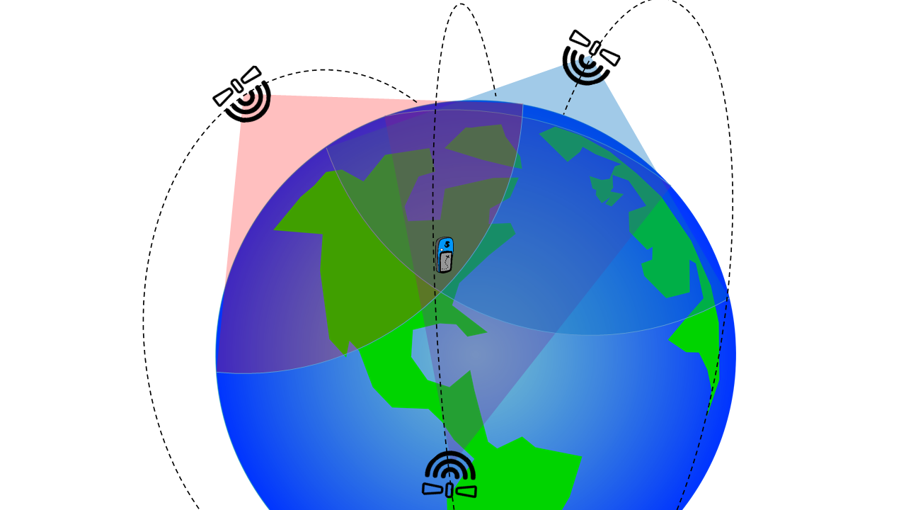
To start, GPS satellites are very punctual: each satellite has its own atomic clock. Each one knows exactly what time it is and exactly where it is above the earth. Once in orbit, GPS satellites essentially just shout the exact time and date, their name, and their location toward the Earth’s surface. They do this over and over again every millisecond. Think of them like super-fancy, space-bound lighthouses. Your GPS device needs at least three of these satellites to perform its calculations, called trilateration.
Trilateration is how your device determines your location on the surface of the Earth. If it can hear three satellites shouting at it and it listens long enough, it can calculate its distance from them using each satellite’s known position (a fact it knows from the ephemeris data it stores and also receives as part of each satellite’s transmission), and the time it takes for each satellite’s signal to travel from the satellite to the receiver.
Civilian GPS is accurate to (at worst) 4 meters on the horizontal plane (it’s worse at accurately guessing your altitude, which is why many GPS units have barometric altimeters built into them), but upgrades to hardware, software, and computing power are always improving that accuracy. It’s not uncommon to see accuracies of better than 2 meters on modern devices, which is sufficient for sports like running, cycling, hiking, and rowing.
Most wearables (e.g. FitBits and Jawbones) lack a GPS radio and so must use the A-GPS services on your phone (to be discussed later), but many fitness watches contain them (e.g. Garmin watches, the TomTom Runner, and many Polar models). Fitness watches like these are convenient because they don’t make you bring your phone on your run with you—nice if you’re in a city as humid as Washington, D.C.! Nobody likes phonesweat.
Not quite perfect
Since its introduction, GPS has stood the test of time and proven itself a great platform for other innovations. However, GPS has its limitations. The first is interference. We discussed earlier how GPS satellites shout the time and their position details; the truth is that, to receivers on the surface of the Earth, that “shout” is really more of a whisper. GPS satellites whiz around the Earth at an altitude of about 12,550 miles, shooting signals through multiple layers of charged particles surrounding the Earth. These particles distort GPS signals, causing errors and signal loss. Combine that with signals bouncing off buildings, airwaves that are crowded with other signals and transmissions, and cheap hardware, creating a torturous path for our dedicated little GPS transmission.
The second limitation faced by the GPS protocol is lack of bandwidth. Because GPS signals are limited in the amount of data they can deliver at a certain time, GPS receivers take a long time to download important information about the satellites shouting whispering at them. Time and location data doesn’t require much bandwidth for the satellites, but other transmitted data, like ephemeris data and updates to the GPS almanac can take up to 12.5 minutes to download. And for someone just trying to find a local falafel shop, 12.5 minutes simply won’t do. Fortunately, there is hope for you falafel hunters. Your mobile phone can use techniques other than GPS to ascertain your location, as we’ll discuss below.
A-GPS
Assisted GPS (A-GPS, or aGPS) is a technology used by mobile phones that contain both a GPS receiver and a cellular data radio to improve the Time to First Fix (TTFF), or the amount of time required before your device can tell you your location with reasonable accuracy. A-GPS essentially takes care of the bandwidth-heavy parts of the GPS signal using your mobile data subscription (a cakewalk for robust cellular 4G services).
Remember that ephemerides info we talked about earlier? That’s the data your mobile connection takes care of. A-GPS is very common in modern smartphones for a few reasons:
- Phones have to operate in environments with lots of interference (like buildings, trees, airborne particulate, and other radio signals) that make it hard for GPS to find satellites
- Quick TTFF is crucial for convenience
- GPS radios tend to gobble up the small batteries found in mobile phones, so the quicker a GPS fix can be acquired, the quicker the phone’s software can turn it off again to save power
When you go for a run with your wearable, your phone uses A-GPS to find your initial location, then GPS to track your location as you jog about. It then pairs that with your device’s step counter to determine your length of stride and other measurements.
Tower Triangulation
Mobile phones can also use cellular towers to trilaterate, but because a mobile phone is generally only in range of one or two towers, location accuracy is greatly reduced. But because towers can automatically track phones whenever and wherever those phones communicate with them, tower triangulation is often used by law enforcement and emergency services to track mobile phone users.
For a pretty neat visualization of cell tower triangulation, check out a 2010 feature made by the German site Zeit Online. For the feature, German Green party politician Malte Spitz provided Zeit with six months worth of phone location data (data Spitz sued to have released by Deutsche Telekom). Zeit combined the data with Spitz’s tweets, blog posts, and other publicly available updates on his life to create a visualization of his travels over that six-month period. To be fair, Zeit tidied up Spitz’s travel routes quite a bit, as you can probably see from his routes along the highway where only one or two towers were available at a time.
Indoor Location
The next frontier of location services is indoors. Ever been lost in a mall? Or lost someone else in a mall? Indoor location services will soon help fix (and hopefully prevent) either of those things, and more—the Federal Communications Commission recently published regulations mandating indoor location specifications for mobile phone 911 calls. These specifications will create a floor for mobile phone 911 location accuracy, hopefully setting the stage for future improvements in indoor location services.
Most indoor location services use either Wi-Fi or Bluetooth, such as Apple’s iBeacon, to locate users. You don’t have to connect to any specific Wi-Fi router to receive location data from it, as most broadcast their location information to all devices in their range. Based on the strength of the Wi-Fi signal and others in range, your phone can calculate its rough location inside a building.
Your phone’s ability to discern its location from just Wi-Fi routers is spotty, however, as thick walls, plumbing, and foliage often distort the high frequency signals from Wi-Fi routers, causing your phone to mistake its true distance from the router. More accurate are Bluetooth beacons, which use the same frequency as Wi-Fi’s lower band but broadcast at a lower power, requiring phones and other devices to be closer to the Bluetooth beacon in order to receive location information from it.
To sum it all up…
Tracking health and fitness through wearables and apps has been our focus this summer for We Wear It, and location tracking is a huge part of that. As technology continues to improve and innovate, that tracking is only going to get easier and more accurate. Maybe someday it will even completely make up for my terrible sense of direction!
Image: adapted from clipart by stevepetmonkey, Gerald_G, and przemof / license